Traffic & autonomous-driving annotation
Traffic video is where annotation quality becomes a safety issue. Perception models for autonomous vehicles, ADAS, and smart-city analytics are only as reliable as the labeled data behind them-and traffic scenes are among the hardest to label: dozens of objects per frame, constant occlusion, tiny distant objects, motion blur, and night scenes.
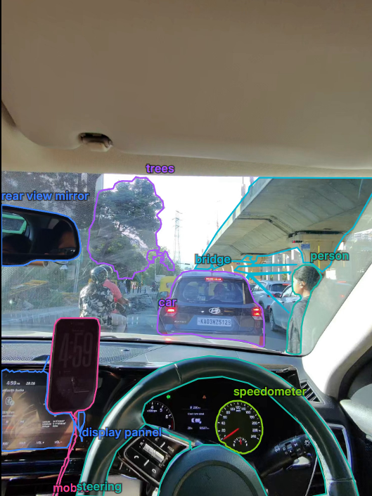
What we annotate in traffic scenes
A production traffic dataset is rarely one label type. It combines several, and our pipeline supports all of them natively in the same project workspace.
| Label type | Traffic use | Typical classes |
|---|---|---|
| Bounding boxes | Vehicle & pedestrian detection | car, bus, truck, motorcycle, bicycle, auto-rickshaw, pedestrian |
| Instance segmentation | Pixel-accurate vehicle shape, free-space | per-vehicle polygon masks |
| Semantic segmentation | Road-scene understanding | road, lane marking, sidewalk, vegetation, sky |
| Video object tracks | Multi-object tracking (MOT), trajectory | persistent per-vehicle identity across frames |
| Classification tags | Scene-level attributes | day/night, weather, congestion, intersection type |
How AI-assisted traffic labeling works
An annotator clicks once on a vehicle and the GPU-backed segmentation engine returns a clean, tight polygon in about a second. For video, tracking then propagates that object through the entire clip-a mask on every frame, not sparse keyframes joined by interpolation, which drifts on turning or braking vehicles.
Occlusion handling is built into the tracker: when a car disappears behind a bus, the track is marked outside rather than hallucinating a box, then resumes the same identity when the car re-emerges. Motion-adaptive smoothing removes boundary flicker without lagging genuinely fast motion.
Regional realism most datasets miss
Detectors trained only on Western freeway footage fail on dense, mixed traffic-two-wheelers weaving between lanes, auto-rickshaws, hand carts, pedestrians crossing mid-block, unmarked lanes. Operating from India, we label the real distribution of South-Asian road scenes as fluently as structured highway footage-precisely the gap most global AV datasets leave open.
Formats & delivery
Traffic datasets export directly into the formats perception teams train with: COCO JSON for detection and instance segmentation, YOLO text labels with a generated data.yaml, Pascal VOC XML for legacy pipelines, and PNG masks for semantic segmentation. Every export is a versioned snapshot with a reproducible train/valid/test split.